Orbivis is an independent space and geospatial advisory practice supporting global organisations entering and operating in Australia. We specialise in space partnerships, on-ground representation, GEOINT, and strategic geospatial solutions that help space companies, Defence, government, and industry make informed decisions.
With expertise across market entry, business development, satellite data solutions, and space-based intelligence, Orbivis connects international innovation with Australia’s growing space ecosystem.
Explore how we support government, defence, and industry use cases
GEOINT & Maritime Domain Awareness (MDA) →
Persistent maritime intelligence for vessel tracking and dark ship detection.
Built for border security and operational awareness.....
Explore this capability →
Land & Infrastructure Disturbance Monitoring →
Millimetre-level ground movement detection from space.
Identify infrastructure risk before failure occurs.....
See how this is applied →
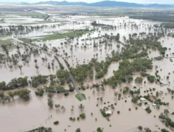
Flood Mapping & Post-Disaster Assessment →
Near real-time flood mapping from satellite radar.
Inform emergency response and post-disaster recovery…
View use cases →
🚀 Impressed by Japan’s Space Domain Defense Guidelines setting a clarity benchmark
Impressed by the conciseness of Japan’s newly released Space Domain Defense Guidelines — and the strong use of graphics to make complex concepts like SDA, resilient SATCOM, EO, and space protection easy to grasp.
🧑🚀 From Australia’s first astronaut trained under our own flag to new research partnerships,
#IAC2025 highlighted a nation on the rise in space capability — across PNT, EO analytics, SSA,
and access-to-space. Proud to help connect data, insight, and innovation to outcomes.
🛰️ Japan moves from owning satellites to buying outcomes
Japan’s Ministry of Defense is shifting toward constellation-based ISR delivered as a service — prioritising persistence, resilience, and faster decision cycles over episodic collection.
🐟 When “civilian” fleets behave like coordinated systems
New reporting highlights unusually large, coordinated fishing formations in the East China Sea — illustrating how scale and coordination can complicate maritime domain awareness and pattern-of-life analysis.
🛰️ Electronic warfare resilience is becoming critical for space-enabled ISR and GEOINT
As reliance on satellite-derived intelligence grows, resilience against EW, RF interference and contested spectrum environments is increasingly shaping how SAR, communications and downstream analytics are designed and operated.
Assess revisit opportunities, tasking feasibility and satellite intelligence coverage for your area of interest. Orbivis helps organisations translate space-based insight into operational decision advantage.
For detailed analysis SAR Tasking & Revisit Intelligence visit our
Orbit Explorer
page.
Pinpoint your area of interest to request a SAR tasking